Pir Panjal
| Author:Laxman Burdak, IFS (Retd.) |

Pir Panjal or Pir Pantsal is Range of mountains in the Inner Himalayan region.
Variants of name
- Panchasattra - province mentioned in Rajatarangini. [1]
- Peer Panjal
- Pir Panjal
- Pir Pantsal
Location
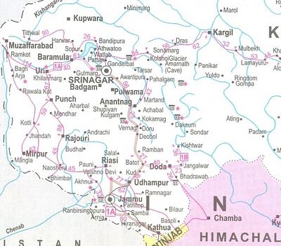
It is running from east-southeast to west-northwest across the Indian states of Himachal Pradesh and Indian controlled Jammu and Kashmir and Pakistan administered Kashmir. The Himalayas show a gradual elevation towards the Dhauldhar and Peer Panjal ranges. Pir Panjal is the largest range of the lower Himalayas. Near the bank of the Sutlej River, it dissociates itself from the Himalayas and forms a divide between the rivers Beas and Ravi River on one side and the Chenab on the other. The famous Murree and Galliat mountains are also located in this range.
In Rajatarangini
Rajatarangini[2] tells...Having thus beaten and subjugated his own relatives, Shankaravarmma made preparations for foreign conquests. Though the country was weak in population, he was able to set out with nine hundred thousand foot, three hundred elephants, and one hundred thousand horse. He, whose command had been ill obeyed in his own kingdom a short while before, now began to pass orders on kings.
[p.116]: His army was joined by the forces of tributary kings, and increased as he went on. On his approach the king of Darvabhisara fled in terror and there was no fighting. The Kashmirian army caught several lions and confined them in a fort, a sort of abode in which they had never lived before. The king then marched for the conquest of Gurjjara. Prithivi-chandra the king of Trigarta hid himself, but his son Bhuvanachandra, on whom the king of Kashmira had bestowed wealth before, came to pay homage. But when he saw the large army of Kashmira, he became afraid of being captured, and accordingly turned and fled. The king of Kashmira, whom the historians describe as a very handsome man, was regarded by other kings as Death. Shankaravarmma easily defeated Alakhāna king of Gurjjara who ceded Takka a part of his kingdom to his conqueror. The king of the Thakkiyaka family took service as guard under the king of Kashmira. The latter caused the kingdom of the Thakkiya king which had been usurped by the king of Bhoja to be restored to him. The king of the country which lay between Darat and Turushka, (as the Aryavarta lies between Himalaya and Vindhya,) Lalliya Shahi by name, who was among kings even as the sun is among stars, and was also lord over Alakhāna, did not submit to the king of Kashmira, on which the latter drove him out of his country.
After his conquest, Shankaravarmma returned to his country, and built a town named after him in the
[p.117]: province of Panchasattra. In that beautiful town he also set up two images of Shiva, Shankaragaurisha and Sugandhesha — the former named after himself, and the latter after his queen Sugandha, daughter of Shrisvami, king of Udakpatha.
[p.121]: He built a town named Pattana, and made his minister Sukharaja's nephew (sister's son) lord of Dvara, but that man lost his life at Bīrānaka through his own carelessness. This incensed the king, and he marched upon, and devastated Biranaka, and entered Uttarapatha. He conquered many kingdoms on the banks of the Indus, and when the affrighted people of those places submitted, he returned.
Important Peaks
Deo Tibba (6,001 m) and Indrasan (6,221 m) are two important peaks at the eastern end of the mountain range. They can be approached from both the Parvati-Beas Valley (Kulu District) and the Chandra (Upper Chenab) Valley (Lahaul and Spiti District) in Himachal Pradesh. The hill station of Gulmarg in Kashmir lies in this range.
Passes in Pir Panjal Range
The Pir Panjal pass lies to the west of Srinagar.
The Banihal pass (2,832 m) lies at the head of the Vitasta river at the southern end of the Kashmir valley. Banihal and Qazigund lie on either side of the pass.
The Sinthan pass connects Jammu and Kashmir with Kishtwar.
Pir ki Gali connects Kashmir valley with Rajouri and Poonch via Mughal road. Pir ki Gali is the highest point of Mughal road (11500 ft approx) and lies to the south west of the Kashmir valley. Nearest town to Pir Ki Gali is Shupian, the apple town of Kashmir valley.
Munawar pass Lies in the North of Pir ki Gali and over looks the town of Rajouri. Munawar pass witnessed some of the heaviest fighting during Operation Gibraltar and was held by a Pakistani Force commanded by Major Malik Munawar Khan Awan who later seized Indian Garrison of Rajouri. The pass was named after him by the locals.
Rohtang La (altitude 3,978 m ) is a mountain pass on the eastern Pir Panjal range connecting Manali in the Kullu Valley to Keylong in the Lahaul Valley.
Coordinates: 33°53′36″N 74°29′19″EHaji Pir Pass (altitude 2,637 m ) on the western Pir Panjal range on the road between Poonch and Uri is in the area of Kashmir administered by Pakistan. The pass, and therefore the strategically significant road, was taken from the control of Indian forces and others connected to that country by the Pakistan Army in 1947.
Jat clans
External links
References
- ↑ Rajatarangini of Kalhana:Kings of Kashmira/Book V (p.117)
- ↑ Rajatarangini of Kalhana:Kings of Kashmira/Book V,p.115-117,121
Back to Mountains

