Wadegaon
| Author:Laxman Burdak, IFS (R) |


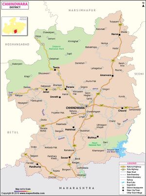
Wadegaon (वाड़ेगांव) is a village in Pandhurna tahsil in Chhindwara district of Madhya Pradesh. It is mentioned as Varuchcha (वारुच्च) in Pandhurna Plates of 29th year of Pravarasena II[1].
Variants
- Waregaon/Varegaon (वारेगांव)
- Varuchcharajya (वारुच्चराज्य) in Pandhurna Plates of 29th year of Pravarasena II[2].
- Varuchcha (वारुच्च) in Pandhurna Plates of 29th year of Pravarasena II[3].
Location
Jat Gotras Namesake
- Vaire (वैरे) (Jat clan) → Varegaon (वारेगांव) = Varuchcha (वारुच्च). Wadegaon (वाड़ेगांव) is a village in Pandhurna tahsil in Chhindwara district of Madhya Pradesh. It is mentioned as Varuchcha (वारुच्च) in Pandhurna Plates of 29th year of Pravarasena II[4].
History
Pandhurna Plates of 29th year of Pravarasena II[5] are said to have been found in 1942 when the old house of one Kadu Patil was being demolished at Tigaon, a village six miles north by West from Pandhurna on the Itarsi-Nagpur line of the Central Railway, in the Chhindwara District of Madhya Pradesh. ...The object of the present inscription was to record the gift of two thousand nivartanas of land in the village Dhuvavataka (धुव वाटक) included in the territorial division of Varuchcharajya (वारुच्चराज्य) to several Brahmanas. ...This donated land was given in exchange for another village named Vijayapallivataka (विजयपल्ली वाटक).....Dhuvavataka (धुववाटक), situated in (the territorial division called) Varuchcha-rajya (वारुच्चराज्य) which lies in the low ground by the western boundary of the village Brahmanavataka (ब्राह्मणवाटक), to the north of the way to the village Ajakarna (अजकर्ण), to the east of the village Badarigrama (बदरीग्राम) and to the west of (the village) Darbhapatha (दर्भपथ).....One of the donees of the original grant resided at Kallara (काल्लार). The first piece of land was situated in the village of Lekhapallika (लेखपल्लिका) and the second in that of Sangamika (संगमिका), both being included in the territorial division called Arammirajya (आरम्मिराज्य).
Vijayapallivataka (विजयपल्ली वाटक) may be Bijagora (बिजगोरा) on the left bank of the Kanhan River, about four miles to the north of the Multai-Chhindwara road.
Varuchcha (वारुच्च), the headquarters of the Varuchcharajya (वारुच्चराज्य), may be Varegaon (वारेगाँव), about four miles west of Pandhurna.
Dhuvavataka (धुव वाटक), the village in which the donated land was situated, cannot now be traced, but two of its boundary villages still exist in the neighbourhood of Tigaon.
Badarigrama (बदरीग्राम) may be modern Borgaon (बोरगाँव) which lies about two miles to the north, and
Ajakarna (अजकर्ण) may be the same as Ajangaon (अजनगांव), about four miles south by east of Tigaon.
Lekhapallika (लेखपल्लिका) and Sangamika (संगमिका) villages mentioned in the spurious third plate as situated in the territorial division of Arammi-rajya may be identical with Lakhapur near Chikhali on the Multai-Chhindwara road, and
Sangam (संगम) near the confluence of the rivers Kanhan River and Bel River.
Arammi (आरम्मि), the headquarters of the territorial division in which they were situated, may be identical with Amla, a station on the Itarsi-Nagpur line of the Central Railway. Arammirajya (आरम्मिराज्य) is also mentioned in the Dudia plates1 which, again, were found in the Chhindwara District.
Kallara (काल्लार) where the Brahmana Somarya was residing may be Kherli, about 13 miles north of Multai.
The other places cannot be identified.
1 No. 10, line 13.
Notable persons
Population
External links
References
- ↑ Corpus Inscriptionum Indicarum Vol.5 (Inscriptions of The Vakatakas), Edited by Vasudev Vishnu Mirashi, 1963, Archaeological Survey of India, p.63-68
- ↑ Corpus Inscriptionum Indicarum Vol.5 (Inscriptions of The Vakatakas), Edited by Vasudev Vishnu Mirashi, 1963, Archaeological Survey of India, p.63-68
- ↑ Corpus Inscriptionum Indicarum Vol.5 (Inscriptions of The Vakatakas), Edited by Vasudev Vishnu Mirashi, 1963, Archaeological Survey of India, p.63-68
- ↑ Corpus Inscriptionum Indicarum Vol.5 (Inscriptions of The Vakatakas), Edited by Vasudev Vishnu Mirashi, 1963, Archaeological Survey of India, p.63-68
- ↑ Corpus Inscriptionum Indicarum Vol.5 (Inscriptions of The Vakatakas), Edited by Vasudev Vishnu Mirashi, 1963, Archaeological Survey of India, p.63-68

